Welcome to my travel blog. Here you can find information related to all major cities airports, city description, places to visit in a city , dine in a city , hotels to stay in and many more information related to a particular destination. You can also book flights or message us for same. We book all major airlines to and from USA with cheap tickets. Kindly follow us on all the channels or links as mentioned in our posts.
9-day honeymoon itinerary in Colombia, including luxurious and boutique hotel stays, transportation options, places to visit, top restaurants, and activities: Day 1: Arrival in Bogotá ** Accommodation **: Four Seasons Hotel Casa Medina - A historic and elegant hotel with spacious rooms and luxurious amenities. - ** Transportation **: Private airport transfer to the hotel. - ** Activities **: - Check-in and relax after your flight. - Evening stroll in Zona G , the city's gourmet district. - ** Dining **: Dinner at Harry Sasson , known for its fusion of Colombian and international cuisine in a stylish setting. Day 2: Explore Bogotá - ** Activities **: - Morning visit to the Gold Museum , home to an impressive collection of pre-Columbian gold artifacts. - Explore the historic La Candelaria district with its colorful colonial buildings and street art. - Take a cable car up to Monserrate for panoramic views of the city. - ** Dining **: ...
Tanzania, East African country situated just south of the Equator. Tanzania was formed as a sovereign state in 1964 through the union of the theretofore separate states of Tanganyika and Zanzibar. Mainland Tanganyika covers more than 99 percent of the combined territories’ total area. Mafia Island is administered from the mainland, while Zanzibar and Pemba islands have a separate government administration. Dodoma, since 1974 the designated official capital of Tanzania, is centrally located on the mainland. Dar es Salaam is the largest city and port in the country.
The Tanzania mainland is bounded by Uganda, Lake Victoria, and Kenya to the north, by the Indian Ocean to the east, by Mozambique, Lake Nyasa, Malawi, and Zambia to the south and southwest, and by Lake Tanganyika, Burundi, and Rwanda to the west.
Because of its numerous lakes, approximately 22,800 square miles (59,000 square km) of Tanzania’s territory consists of inland water. Lake Victoria, which ranks as the world’s second largest freshwater lake, is not part of the Rift System. Although Tanzania has no big rivers, it forms the divide from which the three great rivers of the African continent rise — the Nile, the Congo, and the Zambezi, which flow to the Mediterranean Sea, the Atlantic Ocean, and the Indian Ocean, respectively. Separated by the central plateau, the watersheds of these rivers do not meet.
All of Tanzania’s major rivers — the Ruvuma, the Rufiji, the Wami, and the Pangani — drain into the Indian Ocean. The largest, the Rufiji River, has a drainage system that extends over most of southern mainland Tanzania. The Kagera River flows into Lake Victoria, whereas other minor rivers flow into internal basins formed by the Great Rift Valley. With so many rivers, mainland Tanzania is rich in hydroelectricity potential.
The variety of soils in mainland Tanzania surpasses that of any other country in Africa. The reddish brown soils of volcanic origin in the highland areas are the most fertile. Many river basins also have fertile soils, but they are subject to flooding and require drainage control. The red and yellow tropical loams of the interior plateaus, on the other hand, are of moderate-to-poor fertility. In these regions, high temperatures and low rainfall encourage rapid rates of oxidation, which result in a low humus content in the soil and, consequently, a clayey texture rather than the desired crumblike structure of temperate soils. Also, tropical downpours, often short in duration but very intense, compact the soil; this causes drainage problems and leaches the soil of nutrients.
Mainland Tanzania can be divided into four principal climactic and topographic areas: the hot and humid coastal lowlands of the Indian Ocean shoreline, the hot and arid zone of the broad central plateau, the high inland mountain and lake region of the northern border, where Mount Kilimanjaro is situated, and the highlands of the northeast and southwest, the climates of which range from tropical to temperate. Tanzania’s warm equatorial climate is modified by variations in elevation. The high amount of solar radiation throughout the year is associated with a limited seasonal fluctuation of temperature: the mean monthly variation is less than 9 °F (5 °C) at most stations. Ground frosts rarely occur below 8,200 feet (2,500 metres).
Rainfall is highly seasonal, being influenced greatly by the annual migration of the intertropical convergence zone. Roughly half of mainland Tanzania receives less than 30 inches (750 mm) of precipitation annually, an amount considered to be the minimum required for most forms of crop cultivation in the tropics.
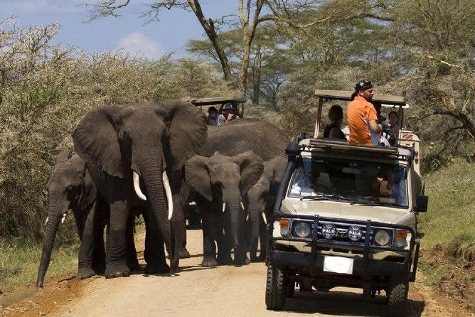
about one-fourth of Tanzania’s land has been set aside to form an extensive network of reserves, conservation areas, and national parks, a number of which — including Serengeti National Park, the Selous Game Reserve, the Ngorongoro Conservation Area, and Kilimanjaro National Park — have been designated UNESCO World Heritage sites.
The islands of Zanzibar and Pemba are located in the Indian Ocean. Zanzibar is 22 miles (35 km) off the coast of mainland Tanzania; Pemba, 35 miles (56 km). Low-lying Pemba, whose highest point reaches an elevation of 311 feet (95 metres), and Zanzibar, which reaches 390 feet (119 metres), are islands whose structure consists of coralline rocks. The west and northwest of Zanzibar consist of several ridges rising above 200 feet (60 metres), but nearly two-thirds of the south and east are low-lying. Pemba appears hilly because the level central ridge has been gullied and eroded by streams draining into numerous creeks.
Tanzania has two official languages, Swahili (kiSwahili) and English. Swahili, the national language, is a composite of several Bantu dialects and Arabic that originated along the East African coast and on the island of Zanzibar. Swahili is the lingua franca of the country, and virtually all Tanzanians speak it. Since independence the government and other national institutions have promoted the use of Swahili through literature, local drama, and poetry. Swahili is also used as the medium of instruction in the first seven years of primary education. English is the medium of instruction at higher levels of education and is widely used in government offices.
Diamonds, gold, kaolin, gypsum, tin, and various gemstones, including tanzanite, are mined in Tanzania. Gold is an important resource and the country’s most valuable export. There are large exploitable deposits of coal in the southwest, phosphate deposits in Arusha, and nickel in the Kagera region. Natural gas has been discovered at Songo Songo Island. Several international companies have been involved in onshore and offshore petroleum exploration.
Imported petroleum, hydroelectric power, and coal are the main sources of commercial energy. Firewood and charcoal are the major domestic fuels, contributing to a growing concern about deforestation.
Tanzania’s industry is based on the processing of its agricultural goods and on import substitution — that is, the manufacture (often from imported materials and parts) of products that were once purchased from abroad. The principal industries are food processing, textiles, brewing, and cigarette production. Production of cement, clothing, footwear, tires, batteries, and bottles takes place as well. There are a number of steel mills and a large pulp and paper mill. Bicycles are also manufactured.
Tanzania’s rapidly expanding tourism sector continues to be a source of great economic promise. Mount Kilimanjaro, the highest peak in Africa, serves as a major tourist attraction, as does the country’s network of national parks, reserves, and conservation areas, which together span some one-fourth of the country. Tanzania’s beaches and coral reefs are also attractive to tourists, and the government has increasingly marketed its coastline and encouraged diving and snorkeling there. Neighbouring Kenya supplies the vast majority of visitors to Tanzania, many of whom visit the country on short day trips. By the early 2000s, tourism accounted for almost one-fifth of the gross domestic product, while the services sector on the whole accounted for almost two-fifths.
Transport in Tanzania spans a wide spectrum, from the motorized means made possible by roads, seaports, airfields, and railways to the traditional carrying of loads by animals and people.
The road network extends to all parts of the country, but it is densest along the coast and southeast of Lake Victoria. Only a fraction of the roadways in Tanzania are paved. The Tanzam Highway, opened in the early 1970s between Dar es Salaam and Zambia, has significantly reduced the isolation of southern Tanzania. Another highway intersects it at Makambako and proceeds southward through the southern highlands to Songea. Government efforts have focused on rehabilitating the trunk road system, which deteriorated with a decline in the importation of maintenance materials during the economic crisis.
Dar es Salaam port, with its deepwater berths, handles the majority of shipping traffic at Tanzanian ports. The remainder goes primarily to Mtwara, Tanga, and the port of the city of Zanzibar.
Several airlines, including the national carrier, Air Tanzania, provide domestic and international service. There are numerous airports throughout the country, including international airports at Dar es Salaam, Kilimanjaro, Mwanza, and Zanzibar; most scheduled international flights land in Dar es Salaam.
The railway system dates back to the pre-World War I German-built Central Railway Line, which bisects the country between Dar es Salaam and Kigoma, and the Tanga-to-Moshi railway. There is also a branch between these two lines, and another line connects Mwanza with Tabora on the Central Line. The Tanzania-Zambia Railway Authority (TAZARA) rail line, running between Dar es Salaam and Kapiri-Mposhi on the Zambian border, was built with Chinese aid in the early 1970s. It provided the main outlet to the sea for Zambia’s copper exports prior to the political changes in South Africa in the 1990s that opened southern transport routes for Tanzania’s landlocked neighbour. Some of the tour partners which can help you out for a better experience as as follows:
1) @shira_tours :They have a package for climbing Kilimanjaro, starting prices 1700$ per person, safari $1400 for 5 days include three national parks.
2) @Kilimanjarowild : There packages include airport pickup and drop off Park fees, transport, food and lodging (hotels and accommodation) Professionals safari and mountain guide (competent in English speaking).
They offer town tours, cultural tours, tanzanite exhibition, children’s day care) (orphanage centre) Local food, coffee and brews processing.. Waterfalls etc
DAY 1
Rongai Gate to Rongai Cave Elevation: 6,398 ft to 9,300 ft Distance: 8 km/5 miles Hiking Time: 3–4 hours Habitat: Rain Forest
We drive from Moshi to Marangu Gate for permits before taking a short transfer to the Rongai Gate trailhead. The path winds through corn and potato fields and then climbs gently through the forest which is home to a variety of wildlife, including the black and white colobus monkey.
DAY 2
Rongai Cave to to Second Cave Elevation: 9,300 ft to 11,300 ft Distance: 6 km/4 miles Hiking Time: 3–4 hours Habitat: Heath
Second Cave to Kikelewa Cave Elevation: 11,300 ft to 11,811 ft Distance: 6 km/4 miles Hiking Time: 3–4 hours Habitat: Heath We begin this morning with a steady incline up to Second Cave. We continue trekking though moorland, leaving the main trail for a smaller path towards the jagged peaks of Mawenzi, before finally arriving at Kikelewa Cave for the night.
DAY 3
Kikelewa Cave to Mawenzi Tarn Elevation: 11,811 ft to 14,160 ft Distance: 5 km/3 miles Hiking Time: 3–4 hours Habitat: Alpine Desert
The hike today is short and steep up a grassy slope. Views of the wilderness area are stunning. As we exit the heath zone and emerge into the Alpine Desert zone, the landscape changes dramatically. Our camp is situated beneath the jagged spires of Mawenzi, at Mawenzi Tarn. The remainder of the day can be spent relaxing or exploring the area.
DAY 4
Mawenzi Tarn to Mawenzi Ridge Elevation (ft): 14,160 ft -14,400 ft Distance: 2 km/1 mile Hiking Time: 1–2 hours Habitat: Alpine Desert
Mawenzi Ridge to Mawenzi Tarn Elevation (ft): 14,400 ft -14,160 ft Distance: 2 km/1 mile Hiking Time: 1–2 hours Habitat: Alpine Desert This is an extra day meant for acclimatization and can be spent day hiking on Mawenzi Ridge. The unique landscape offers motivating views of Kibo and Mawenzi. After spending a few moments exploring the area we head back to Mawenzi Tarn for camp.
DAY 5
Marwenzi Tarn to Kibo Hut Elevation (ft): 14,160 ft to 15,430 ft Distance: 8 km/5 miles Hiking Time: 5–6 hours Habitat: Alpine Desert
We climb gradually, then cross the lunar desert of the “Saddle” between Mawenzi and Kibo. Our camp, Kibo Hut, sits at the bottom of the Kibo crater wall. Once here we rest, enjoy an early dinner to prepare for the summit day.
DAY 6
Kibo Hut to Uhuru Peak Elevation (ft): 15,430 ft to 19,341 ft Distance: 6 km/4 miles Hiking Time: 6–8 hours Habitat: Arctic Uhuru Peak to Horombo Hut Elevation (ft): 19,341 ft to 12,250 ft Distance: 16 km/10 miles Hiking Time: 4–5 hours Habitat: Heath
Very early in the morning (around midnight), we begin our push to the summit. This is the most mentally and physically challenging portion of the trek. The wind and cold at this elevation and time of day can be extreme. We ascend in the darkness for several hours while taking frequent, but short, breaks. At Gilman’s point (18,600 ft), you will be rewarded with the most magnificent sunrise you are ever likely to see coming over Mawenzi Peak. Finally, we arrive at Uhuru Peak- the highest point on Mount Kilimanjaro and the continent of Africa. After spending a few moments taking in the plains of Africa and your accomplishment, we descend to Horombo Hut. Later in the evening, we enjoy our last dinner on the mountain and a well-earned sleep.
DAY 7
Horombo Hut to Marangu Gate Elevation (ft): 12,205 ft to 6,046 ft Distance: 20 km/12 miles Hiking Time: 5–7 hours Habitat: Rain Forest
On our last day, we have a long trek mostly downhill through the tropical rainforest. Once at the park headquarters at Marangu gate, we collect our summit certificates. A vehicle will meet us here and drive us back to the hotel in Arusha
That’s the itinerary for kilimanjaro trek. If you need any more help regarding same. Just give us a call back.
Book Your Flights Here : Subscribe Our Youtube , Instagram , Pinterest , Twitter , Medium Here : Maldives consists of a chain of about 1,200 small coral islands and sandbanks, grouped in clusters, or atolls. The island nation of the Maldives is popular with honeymooners and adventurers looking to explore the depths of the sea on a scuba diving and snorkeling excursion. Travelers can unwind at one of the island spas and all visitors should certainly spend a day exploring the Maldivian capital of Malé. One can find underwater hotels to overwater private bungalows to incredibly beautiful resorts in Maldives. Located between the Arabian and Laccadive seas, roughly 500 miles southwest of Sri Lanka, the Maldives is about as isolated as you can get – and that's just another one of its many allures. The Maldivian race is the result of several waves of settlement from various parts of the Indian subcontinent and thousands ...
Book Your Flights Here : Subscribe Our Youtube , Instagram , Pinterest , Twitter , Medium Here : Bora Bora is a tremendously pricey destination. Everything (catering and activities) ranges from “expensive” to “indescribably expensive”. Bora Bora is an island in the Leeward group of the Society Islands of French Polynesia, located in the Pacific Ocean. The island, located about 230 kilometres (140 mi) northwest of Papeete, is surrounded by a lagoon and a barrier reef. In the center of the island are the remnants of an extinct volcano rising to two peaks, Mount Pahia and Mount Otemanu. The products of the island are mostly limited to what can be obtained from the sea and coconut trees, which were historically of economic importance for copra . Bora Bora is a major international tourist destination, famous for its seaside (and even offshore) luxury resorts . The major settlement, Vaitape , is on the western side ...
Austin-Bergstrom International Airport (AUS) is the primary airport serving Austin, Texas. It's located about 5 miles southeast of downtown Austin. The airport has experienced significant growth in recent years, becoming one of the fastest-growing airports in the United States. Several airlines operate at Austin-Bergstrom International Airport, with some using it as a hub or focus city: 1. Southwest Airlines : Southwest is the largest carrier at AUS and operates the most flights. While not officially a hub, Austin is one of Southwest's focus cities, with many nonstop flights to destinations across the United States and some international routes to Mexico and the Caribbean. 2. American Airlines : American has a significant presence at AUS, offering flights to various destinations across the U.S. and internationally. It operates a few flights out of Austin, but it's not a major hub for the airline. 3. Delta Air Lines : Delta operates flights to several destinati...
San Juan is a great destination for food lovers, as it offers a variety of cuisines and dishes that reflect the diverse and rich culture of Puerto Rico. Whether you are looking for traditional Puerto Rican food, international flavors, or fine dining, you will find something to satisfy your taste buds in San Juan. Here are some of the best places to dine in San Juan : If you want to experience the authentic and delicious Puerto Rican cuisine, you should visit El Nuevo Acuario , a family-owned restaurant that serves fresh seafood, mofongo, rice and beans, and other local specialties. The restaurant is located near the beach and has a cozy and friendly atmosphere. You can also enjoy the live music and dancing on weekends. If you are looking for a more upscale and elegant dining experience, you should try Marmalade Restaurant & Wine Bar , one of the best restaurants in San Juan. The restaurant offers a fusion of Caribbean, international, and vegetarian dish...
Day 1: Arrival and Old San Juan Exploration Arrive in San Juan and check-in at your hotel Start your day with a traditional Puerto Rican breakfast at Caficultura Walk around the colorful streets of Old San Juan and explore the historic landmarks such as El Morro , San Cristobal Fort , and La Fortaleza Have a seafood lunch at La Marea by Chef Maria Germania In the afternoon, visit the Bacardi Distillery for a rum tasting tour In the evening, head to Calle San Sebastian for a vibrant nightlife scene Day 2: Beach Day and Art Museum Spend your morning at the beautiful Isla Verde Beach Have a late breakfast at the famous Kasalta Bakery Visit the Museo de Arte de Puerto Rico to see its vast collection of Puerto Rican and Caribbean art Enjoy lunch at Jose Enrique , a restaurant famous for its authentic Puerto Rican cuisine Spend the rest of the day relaxing on the beach or trying out water sports activities such as paddleboarding or jet skiing Day 3: El Yunque Rainforest and Luquillo ...
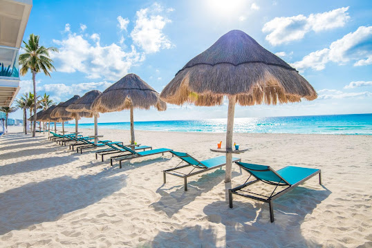
Cancun is a popular tourist destination known for its beautiful beaches, clear blue waters, and vibrant nightlife. Here are a few popular places to visit in Cancun : Chichen Itza : An ancient Mayan city and one of the Seven Wonders of the World, Chichen Itza is a must-visit destination for anyone interested in history and archaeology. Isla Mujeres : A small island located just off the coast of Cancun , Isla Mujeres is known for its stunning beaches and clear waters, making it a popular destination for snorkeling and diving. Xcaret Park : A nature park located just outside of Cancun , Xcaret Park is a great destination for families and offers a range of activities, including snorkeling, swimming with dolphins, and exploring caves. El Rey Ruins : A small Mayan ruin located in the heart of Cancun , El Rey Ruins is a popular destination for history and archaeology enthusiasts. Playa Delfines : A popular public beach located in C...
Some nearby cities to Venice, Italy, worth exploring include: Padua (Padova) : Known for its historic university, stunning frescoes in the Scrovegni Chapel, and charming city center. Verona : Famous for Shakespeare's "Romeo and Juliet," Verona boasts well-preserved Roman architecture, a beautiful arena, and a romantic atmosphere. Treviso : A picturesque town with canals, medieval architecture, and a relaxed ambiance. It's often considered a quieter alternative to Venice. Vicenza : Recognized for its Palladian architecture, Vicenza is a UNESCO World Heritage site with elegant buildings designed by the renowned architect Andrea Palladio. Chioggia : Often referred to as "Little Venice," Chioggia offers a similar canal-laden experience in a smaller and less crowded setting. These cities are easily accessible from Venice and offer diverse cultural and historical attractions, providing a well-rounded expe...
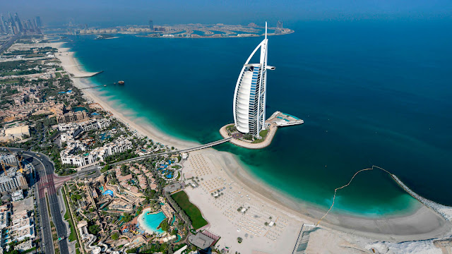
Book Your Flights Here : Subscribe Our Youtube , Instagram , Pinterest , Twitter , Medium Here : Dubai is a city of skyscrapers, ports, and beaches, where big business takes place alongside sun-seeking tourism. Dubai, also spelled Dubayy, city and capital of the emirate of Dubai, one of the wealthiest of the seven emirates that constitute federation of the United Arab Emirates. In recent years Dubai has been compared to Singapore and Hong Kong and is often regarded as the Middle East’s premier entrepot . Islam is the majority religion, but churches and Hindu temples coexist with Dubai’s mosques. Dubai has a year-round hot climate. Humidity is high in the summer months and moderate the rest of the year. Most of the population is also Muslim, although there are significant Christian, Hindu, and Sikh. Dubai is a relatively crime-free place where administrative efficiency and openness to business have encouraged astou...
Book Your Flights Here : Subscribe Our Youtube , Instagram , Pinterest , Twitter , Medium Here : Athens was the largest and most influential of the Greek city-states. It had many fine buildings and was named after Athena, the goddess of wisdom and warfare. The Athenians invented democracy, a new type of government where every citizen could vote on important issues, such as whether or not to declare war. Athens is generally considered to be the birthplace of Western civilization. Athens, with its tall buildings and contemporary shops, is the first European city when approached from the Middle East. When approached from the west, from elsewhere in Europe, what strikes the visitor is the influence of the East—in the food, music, and clamorous street life—perhaps vestiges of a time when Athens was divorced from European society under the yoke of Ottoman rule. Nevertheless, it is wrong to say that Athens is a ...
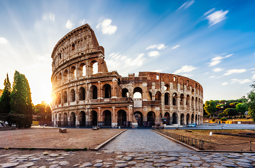
Book Your Flights Here : Subscribe Our Youtube , Instagram , Pinterest , Twitter , Medium Here : Two Thousand years ago this land was the heart of the Roman empire. Rome is the ancient republic catholic capital which is third most visited city in Europe and the fourteenth worldwide. It attracts visitors from all over the world due to its vast and impressive monuments and archaeological sites ; and this city is also known for its amazing cuisine and its lively atmosphere. Rome has a Mediterranean climate with mild winters and warm or hot summers. With 2,500 hours of sun every year, chances are good you will find sunny weather. You can visit Rome in Italy throughout the year, but the best time for tourism is in spring or autumn. The winters tend to be chilly and wet, but there is little chance of snow. Many ruins and excavations can be found in this city along with influence o...


Comments
Post a Comment
Kindly leave your comments